
The viability of a Pumped Storage Hydropower (PSH) project depends entirely on the structural integrity of the site. Before a single cubic meter of concrete is poured, the «Site Integrity» phase determines the technical and economic feasibility of the facility. For projects located in complex mountain massifs, such as the Tien Shan or the Caucasus, this stage is not merely a formality—it is the primary risk-mitigation tool.
1. Topographic Mapping and Geodetic Precision
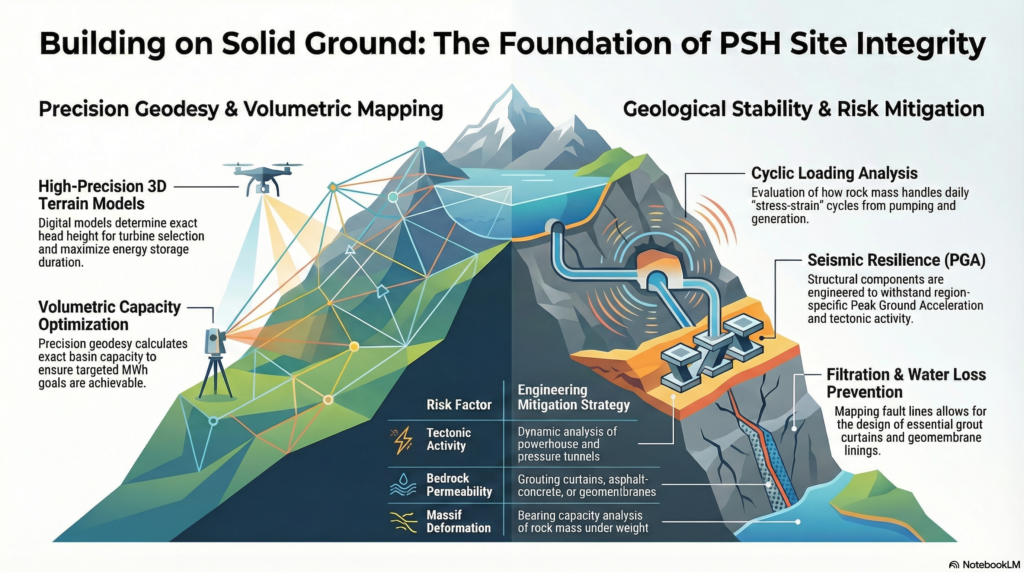
The efficiency of a hydropower plant is a direct function of the Head (H) and the Storage Volume (V). Modern engineering demands more than traditional maps; it requires high-precision 3D digital terrain models (DTM).
- Vertical Accuracy: Determining the exact head is critical for turbine selection (e.g., Francis vs. Pelton units).
- Volumetric Analysis: Precision geodesy calculates the exact capacity of the upper and lower basins, ensuring the required energy storage duration (MWh) is achievable within the natural landscape.
2. Geological Stability and Cyclic Loading
Unlike traditional dams, Pumped Storage reservoirs experience constant «stress-strain» cycles due to the daily pumping and generation phases. This cyclic loading puts immense pressure on the rock mass.
- Bearing Capacity: We analyze the rock’s ability to withstand the weight of full reservoirs without deformation.
- Massif Integrity: Understanding the internal structure of the mountain is essential to prevent landslides or slope failures triggered by the rapid fluctuation of water levels.
3. Seismic Resilience: Engineering for Active Tectonics
For projects located in orogenic belts (mountain-building zones), seismic safety is the highest priority. The engineering must account for Peak Ground Acceleration (PGA) specific to the region.
- Dynamic Analysis: Structural components—including the powerhouse, pressure tunnels, and dams—are calculated to maintain integrity during high-magnitude earthquakes.
- Regional Specifics: In regions like Kazakhstan or Georgia, seismic design ensures that even in the event of tectonic activity, the containment structures prevent catastrophic water release.
4. Hydrogeological Assessment and Filtration Control
Water loss is a direct financial loss. Hydrogeological surveys identify the permeability of the bedrock to ensure the «bowl» of the reservoir is watertight.
- Fracture Analysis: We map fault lines and rock fissures that could lead to «unseen» leaks.
- Grouting and Lining Solutions: Based on the filtration study, we determine the necessity of geomembranes, asphalt-concrete lining, or cement grouting curtains to seal the basins.
Conclusion
Geological and geodetic surveys represent the «zero phase» of hydropower development. For asumbhydro.com, our approach to Site Integrity ensures that every project is built on a foundation of scientific certainty, minimizing environmental risk and maximizing long-term operational stability.
Have questions? Contact us.
Our experts are ready to provide detailed answers and consult you on your project. We ensure a prompt and professional response to every inquiry.